
Mt Haruna榛名山Mt Haruna
Mt Haruna in Gunma is the real mountain behind Akina, the home pass of Initial D's hero. This is what is on the mountain today, which spots fans have identified, and how to visit without causing trouble.群馬県の榛名山は、『頭文字D』の主人公のホームコース「秋名」のモデルとされる実在の山です。現在の山の姿、ファンが特定したスポット、迷惑をかけない訪れ方をまとめました。Mt Haruna in Gunma is the real mountain behind Akina, the home pass of Initial D's hero. This is what is on the mountain today, which spots fans have identified, and how to visit without causing trouble.
Photo: Yones, Public domain, via Wikimedia Commons写真:Yones、Public domain、Wikimedia CommonsPhoto: Yones, Public domain, via Wikimedia Commons
From Akina to Haruna
Initial D is a street racing manga by Shuichi Shigeno. It began in Kodansha's Weekly Young Magazine in 1995 and is set on mountain passes in Gunma. Akina is the pass where the hero, Takumi Fujiwara, drives his father's AE86 and delivers tofu to a hotel by a lake.
Akina is a fictional name. Wikipedia and the Japanese-language Wikipedia article on Mt Haruna both identify Mt Haruna as the model, and Lake Haruna as the model for the lake in the story. Initial D Wikipedia notes that the manga changes some place names but bases its locations on real places.
Touge Town is an independent fan project. We are not affiliated with or endorsed by the Initial D manga, its publisher, its studios or its rights holders.

The mountain and the lake
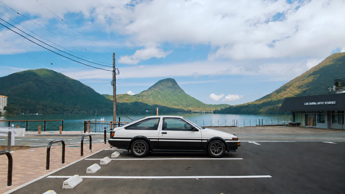
Mt Haruna is a dormant volcano with a high point of 1,449 m. It has a caldera at the top, and Lake Haruna fills the western side of it. Within the caldera the small lava dome Haruna-Fuji rises, and it is often compared to a miniature Mt Fuji. Mt Haruna is one of the Three Mountains of Joshu with Mt Akagi and Mt Myogi.
The lake sits at about 1,084 m, covers roughly 1.15 square kilometres and is up to 12.6 m deep. It lies in the city of Takasaki. By car it takes about 40 minutes from the Shibukawa-Ikaho interchange on the Kan-Etsu Expressway. By bus it takes about 90 minutes from Takasaki Station.
In summer the shore is popular with campers, and boats are available on the water.

Ropeway and shrines
The Harunasan Ropeway runs from Sanroku Station at 1,097 m up to Harunafuji-Sancho Station at 1,366 m. It is 527 m long and the ride takes under three minutes. From April to November it runs 9:00 to 17:00 with the last ascent at 16:30, and from December to March it runs 9:00 to 16:00. Check the operator for weather cancellations and current fares.
Haruna-Fuji Shrine is about a five-minute walk from the top station. The much larger Haruna Shrine is a separate site on the south-western side of the mountain. It was founded in 586, according to Wikipedia, and is dedicated to the gods of water, fire and agriculture.
The road and the downhill start
The road that fans associate with the Akina downhill is Gunma Prefectural Route 33, the Shibukawa-Matsuida line. It runs about 15 km from Lake Haruna down to Ikaho Onsen. It is an ordinary public road with speed limits, oncoming traffic, cyclists and pedestrians.
Shibukawa city's Initial D manhole covers include one showing Takumi's AE86 and Keisuke's RX-7 at the start of their battle. Fun-Japan lists its location as the former Yaseone Pass toll booth site on the Haruna pass. A fan guide on animepilgrimage.com also lists the Yaseone Pass among scene locations. We could not find an official source that gives a precise coordinate, so we give none.
Takane Observatory, on Route 33 near the 23rd curve, is a parking spot with a free car park of 11 spaces and views over Ikaho and toward Mt Akagi. It appears in the story as a night-view location.
Corners fans have named
Fans have matched individual corners to the story. One fan entry on the Japanese car site Minkara marks a corner on a bridge in Ikaho as the place where Takumi passes his rivals in the third corner of two battles. This is one person's identification and the page does not name Haruna directly. Treat it as a low-confidence fan match.
The gutter corner, where Takumi's gutter run is shown, is often discussed by fans. We did not find a source we could open that pins it to a real corner, so we do not name one.
A guide from Samurai Car Japan mentions a short stretch near the lake with grooves cut into the surface so that tyres play a tune at a steady speed. It suggests keeping the windows open and the stereo off.
Visiting responsibly
These are public mountain roads with residents and tourists on them. Drive within the law at all times. Racing or drifting on public roads is illegal and dangerous, and locals are sensitive about late-night driving.
A fan guide warns that the road has little lighting and poor sightlines at night, and that speeding is enforced. Visit in daylight, park only in car parks, and take photos from safe places off the carriageway.
Touge Town's drift day happens only on the closed Gunsai course in Gunma. That is where passengers ride in an AE86. For the town side of the story, see the articles on Ikaho and Shibukawa and the overview.
At a glance
| Highest point of Mt Haruna | 1,449 m ↗ |
|---|---|
| Lake Haruna elevation and depth | About 1,084 m above sea level, maximum depth 12.6 m ↗ |
| Lake Haruna by car | About 40 minutes from Shibukawa-Ikaho IC ↗ |
| Ropeway | 527 m, about 3 minutes, Sanroku 1,097 m to Sancho 1,366 m ↗ |
| Ropeway hours | Apr to Nov 9:00 to 17:00; Dec to Mar 9:00 to 16:00 (last ascent 30 minutes before close) ↗ |
| Haruna Shrine founded | 586, per Wikipedia ↗ |
| Downhill road | Gunma Prefectural Route 33, about 15 km from the lake to Ikaho Onsen ↗ |
| Takane Observatory | On Route 33 near the 23rd curve, free parking for 11 cars ↗ |
The places
The map loads from Google when you press the button. Places without published coordinates are placed by Google’s search and are approximate.
Lake Haruna
The lake and hotel at the top of Akina, where Takumi delivers tofu and where characters meet.
A caldera lake at about 1,084 m on Mt Haruna with boating and camping in summer. Wikipedia names it as the model for the lake in the story.
Harunasan Ropeway, Haruna-Fuji summit station
Not a story location. Fans use Haruna-Fuji as a recognisable landmark of the Akina area.
The upper station of the ropeway on the Haruna-Fuji lava dome, with views over the Kanto Plain and the lake.
Haruna Shrine
Not a named location in the story. It is the main shrine of the mountain behind Akina.
A shrine founded in 586 at 849 Harunasan-cho, on the south-western side of Mt Haruna.
Yaseone Pass, former toll booth site
Fans take it as the start of the Takumi vs Keisuke battle on Akina.
The Shibukawa manhole cover showing the start of that battle is said by Fun-Japan to stand at the former toll booth site. Exact coordinates are not given in any source we opened.
Takane Observatory
A night-view spot in the story.
A small deck on Route 33 at a 1,029 m peak with 11 free parking spaces and views of Ikaho, Shibukawa and Mt Akagi.
Bridge corner
A bridge corner linked by one fan to the Takumi vs Ryosuke and Takumi vs Seiji Iwaki battles, at the third corner.
One Minkara fan entry lists an address in Ikaho and a map point. The page does not name Haruna and there is no second source, so this is unverified.
What we could not confirm
- Touge Town is independent and is not affiliated with or endorsed by the Initial D manga, its publisher, studios or rights holders.
- Corner identifications are fan opinions. The bridge corner rests on one fan entry; the gutter corner is not located.
- Ropeway hours and fares change. Confirm with the operator before travelling.
- Never race or drift on public roads. Touge Town's drift day takes place only on the closed Gunsai course.
Sources
- Mount Haruna (Wikipedia) · Height, Akina model, Three Mountains of Joshu
- Lake Haruna (Wikipedia) · Lake size, depth, elevation, access, coordinates, Akina link
- 榛名山 (Japanese Wikipedia) · Akina model, Route 33, Haruna-Fuji height
- Haruna Shrine (Wikipedia) · Shrine founding date, location, coordinates
- 榛名山ロープウェイ (Japanese Wikipedia) · Ropeway length and station coordinates
- Harunasan Ropeway (Tobu) · Station altitudes, hours, Haruna-Fuji Shrine
- Initial D (Wikipedia) · Author, 1995 start, Kodansha, real-place basis
- Find the Initial D Manhole Covers (Fun-Japan) · Manhole cover at former Yaseone toll booth site
- Initial D Legend 2 map (Anime Pilgrimage) · Yaseone Pass listed as scene location
- Takane Observatory (Tabi-Mag) · Takane Observatory facts
- Akina guide (Samurai Car Japan) · Route 33 length, night and enforcement warnings, melody road
- Corner on the bridge (Minkara fan spot) · Fan-identified bridge corner
- Initial D related places in Haruna and Akagi (Gowithguide) · Yaseone Pass as downhill start, Lake Haruna as hangout
Touge Town is independent and not affiliated with or endorsed by Initial D, its publisher, studios or rights holders. These are public roads: racing or drifting on them is illegal and dangerous. Our drift day runs only on the closed Gunsai course.
作中の秋名と、地図の上の榛名
『頭文字D』はしげの秀一さんによるストリートレース漫画です。1995年に講談社の週刊ヤングマガジンで連載が始まり、群馬県の峠が舞台になっています。秋名は主人公の藤原拓海が父のAE86で走り、湖畔のホテルへ豆腐を届けるホームコースです。
「秋名」は架空の名前です。英語版Wikipediaと日本語版Wikipediaの榛名山の項目は、榛名山をそのモデルとしており、作中の湖のモデルは榛名湖とされています。英語版の『頭文字D』の項目も、地名の一部は変えてあるが実在の場所に基づいていると説明しています。
Touge Townは独立したファンのプロジェクトです。『頭文字D』の原作、出版社、制作会社、権利者とは提携しておらず、公認も受けていません。
山と湖
榛名山は最高点が1,449mの休火山で、山頂部にカルデラがあります。カルデラの西側を榛名湖が占め、中央には溶岩ドームの榛名富士がそびえます。榛名富士はよく小さな富士山にたとえられます。榛名山は赤城山、妙義山とともに上毛三山のひとつです。
湖の標高は約1,084m、面積は約1.15平方キロメートル、最大水深は12.6mで、高崎市に属します。関越自動車道の渋川伊香保ICから車で約40分、高崎駅からバスで約90分です。
夏は湖畔にキャンパーが訪れ、湖上ではボートも利用できます。
ロープウェイと神社
榛名山ロープウェイは、標高1,097mの山麓駅から標高1,366mの榛名富士山頂駅までを結びます。全長は527mで、所要時間は3分弱です。4月から11月は9:00〜17:00(最終上り16:30)、12月から3月は9:00〜16:00の運行です。天候による運休や現在の料金は運営会社に確認してください。
山頂駅から歩いて約5分のところに榛名富士神社があります。それとは別に、山の南西側に規模の大きい榛名神社があり、Wikipediaによれば創建は586年で、水・火・農業の神を祀っています。
道路とダウンヒルのスタート
ファンが秋名のダウンヒルと結びつけているのは、群馬県道33号渋川松井田線です。榛名湖から伊香保温泉まで約15kmの区間で、速度規制があり、対向車、自転車、歩行者がいる普通の公道です。
渋川市の『頭文字D』マンホール蓋のひとつには、拓海のAE86と啓介のRX-7がバトルを始める場面が描かれています。Fun-Japanは、その設置場所を榛名の峠にある旧ヤセオネ峠料金所跡としています。animepilgrimage.comのファン向けガイドも、場面の場所のひとつにヤセオネ峠を挙げています。正確な座標を示す公式の情報は見つからなかったため、座標は載せていません。
県道33号の23番カーブ付近にある高根展望台は、無料駐車場(11台)があり、伊香保の街並みや赤城山方面を望めます。作中では夜景の場面に登場します。
ファンが名前を挙げたコーナー
個々のコーナーを作中の場面に結びつけているファンもいます。日本のクルマ情報サイトみんカラのユーザー投稿には、伊香保にある橋の上のコーナーを、拓海が二つのバトルで3つ目のコーナーで追い抜く場所とするものがあります。これは投稿者個人の特定であり、ページに榛名の名前は出てきません。確度の低いファンの推定として扱ってください。
拓海の溝落としが描かれたコーナーはファンの間でよく話題になりますが、実在のコーナーに特定している確認可能な資料は見つからなかったため、場所は挙げません。
Samurai Car Japanのガイドには、湖の近くに、一定の速度で走るとタイヤが音楽を奏でる溝を刻んだ区間があると書かれています。窓を開けてオーディオを切るよう勧めています。
マナーを守って訪れるには
これらは地元の住民や観光客が使う公道です。常に法令を守って運転してください。公道でのレースやドリフトは違法で危険です。深夜の走行には地元の方も敏感です。
ファン向けガイドは、夜間は照明が少なく見通しが悪いこと、速度違反が取り締まられていることを注意しています。昼間に訪れ、駐車は駐車場に限り、撮影は車道から離れた安全な場所で行ってください。
Touge Townのドリフトデーは、群馬県内の閉鎖されたGunsaiコースだけで行います。同乗走行はそこでAE86に乗っていただきます。町側のストーリーは伊香保と渋川の記事、全体の案内は initial-d-gunma-locations をご覧ください。
場所
ボタンを押すとGoogleマップを読み込みます。位置情報の記載がない場所はGoogleの検索結果に基づく目安です。
榛名湖
The lake and hotel at the top of Akina, where Takumi delivers tofu and where characters meet.
A caldera lake at about 1,084 m on Mt Haruna with boating and camping in summer. Wikipedia names it as the model for the lake in the story.
榛名山ロープウェイ 榛名富士山頂駅
Not a story location. Fans use Haruna-Fuji as a recognisable landmark of the Akina area.
The upper station of the ropeway on the Haruna-Fuji lava dome, with views over the Kanto Plain and the lake.
榛名神社
Not a named location in the story. It is the main shrine of the mountain behind Akina.
A shrine founded in 586 at 849 Harunasan-cho, on the south-western side of Mt Haruna.
ヤセオネ峠(旧料金所跡)
Fans take it as the start of the Takumi vs Keisuke battle on Akina.
The Shibukawa manhole cover showing the start of that battle is said by Fun-Japan to stand at the former toll booth site. Exact coordinates are not given in any source we opened.
高根展望台
A night-view spot in the story.
A small deck on Route 33 at a 1,029 m peak with 11 free parking spaces and views of Ikaho, Shibukawa and Mt Akagi.
橋の上のコーナー(ファン特定)
A bridge corner linked by one fan to the Takumi vs Ryosuke and Takumi vs Seiji Iwaki battles, at the third corner.
One Minkara fan entry lists an address in Ikaho and a map point. The page does not name Haruna and there is no second source, so this is unverified.
確認できなかったこと
- Touge Town is independent and is not affiliated with or endorsed by the Initial D manga, its publisher, studios or rights holders.
- Corner identifications are fan opinions. The bridge corner rests on one fan entry; the gutter corner is not located.
- Ropeway hours and fares change. Confirm with the operator before travelling.
- Never race or drift on public roads. Touge Town's drift day takes place only on the closed Gunsai course.
出典
- Mount Haruna (Wikipedia) · Height, Akina model, Three Mountains of Joshu
- Lake Haruna (Wikipedia) · Lake size, depth, elevation, access, coordinates, Akina link
- 榛名山 (Japanese Wikipedia) · Akina model, Route 33, Haruna-Fuji height
- Haruna Shrine (Wikipedia) · Shrine founding date, location, coordinates
- 榛名山ロープウェイ (Japanese Wikipedia) · Ropeway length and station coordinates
- Harunasan Ropeway (Tobu) · Station altitudes, hours, Haruna-Fuji Shrine
- Initial D (Wikipedia) · Author, 1995 start, Kodansha, real-place basis
- Find the Initial D Manhole Covers (Fun-Japan) · Manhole cover at former Yaseone toll booth site
- Initial D Legend 2 map (Anime Pilgrimage) · Yaseone Pass listed as scene location
- Takane Observatory (Tabi-Mag) · Takane Observatory facts
- Akina guide (Samurai Car Japan) · Route 33 length, night and enforcement warnings, melody road
- Corner on the bridge (Minkara fan spot) · Fan-identified bridge corner
- Initial D related places in Haruna and Akagi (Gowithguide) · Yaseone Pass as downhill start, Lake Haruna as hangout
独立した企画で、いかなるシリーズ・出版社・制作会社・権利者とも提携・承認関係にありません。公道は実在の生活道路です。路上でのレース・ドリフトは違法で危険です。ドリフトデーは閉鎖された群サイのコースでのみ行います。
本页暂无中文译本,以下为英文原文。
From Akina to Haruna
Initial D is a street racing manga by Shuichi Shigeno. It began in Kodansha's Weekly Young Magazine in 1995 and is set on mountain passes in Gunma. Akina is the pass where the hero, Takumi Fujiwara, drives his father's AE86 and delivers tofu to a hotel by a lake.
Akina is a fictional name. Wikipedia and the Japanese-language Wikipedia article on Mt Haruna both identify Mt Haruna as the model, and Lake Haruna as the model for the lake in the story. Initial D Wikipedia notes that the manga changes some place names but bases its locations on real places.
Touge Town is an independent fan project. We are not affiliated with or endorsed by the Initial D manga, its publisher, its studios or its rights holders.
The mountain and the lake
Mt Haruna is a dormant volcano with a high point of 1,449 m. It has a caldera at the top, and Lake Haruna fills the western side of it. Within the caldera the small lava dome Haruna-Fuji rises, and it is often compared to a miniature Mt Fuji. Mt Haruna is one of the Three Mountains of Joshu with Mt Akagi and Mt Myogi.
The lake sits at about 1,084 m, covers roughly 1.15 square kilometres and is up to 12.6 m deep. It lies in the city of Takasaki. By car it takes about 40 minutes from the Shibukawa-Ikaho interchange on the Kan-Etsu Expressway. By bus it takes about 90 minutes from Takasaki Station.
In summer the shore is popular with campers, and boats are available on the water.
Ropeway and shrines
The Harunasan Ropeway runs from Sanroku Station at 1,097 m up to Harunafuji-Sancho Station at 1,366 m. It is 527 m long and the ride takes under three minutes. From April to November it runs 9:00 to 17:00 with the last ascent at 16:30, and from December to March it runs 9:00 to 16:00. Check the operator for weather cancellations and current fares.
Haruna-Fuji Shrine is about a five-minute walk from the top station. The much larger Haruna Shrine is a separate site on the south-western side of the mountain. It was founded in 586, according to Wikipedia, and is dedicated to the gods of water, fire and agriculture.
The road and the downhill start
The road that fans associate with the Akina downhill is Gunma Prefectural Route 33, the Shibukawa-Matsuida line. It runs about 15 km from Lake Haruna down to Ikaho Onsen. It is an ordinary public road with speed limits, oncoming traffic, cyclists and pedestrians.
Shibukawa city's Initial D manhole covers include one showing Takumi's AE86 and Keisuke's RX-7 at the start of their battle. Fun-Japan lists its location as the former Yaseone Pass toll booth site on the Haruna pass. A fan guide on animepilgrimage.com also lists the Yaseone Pass among scene locations. We could not find an official source that gives a precise coordinate, so we give none.
Takane Observatory, on Route 33 near the 23rd curve, is a parking spot with a free car park of 11 spaces and views over Ikaho and toward Mt Akagi. It appears in the story as a night-view location.
Corners fans have named
Fans have matched individual corners to the story. One fan entry on the Japanese car site Minkara marks a corner on a bridge in Ikaho as the place where Takumi passes his rivals in the third corner of two battles. This is one person's identification and the page does not name Haruna directly. Treat it as a low-confidence fan match.
The gutter corner, where Takumi's gutter run is shown, is often discussed by fans. We did not find a source we could open that pins it to a real corner, so we do not name one.
A guide from Samurai Car Japan mentions a short stretch near the lake with grooves cut into the surface so that tyres play a tune at a steady speed. It suggests keeping the windows open and the stereo off.
Visiting responsibly
These are public mountain roads with residents and tourists on them. Drive within the law at all times. Racing or drifting on public roads is illegal and dangerous, and locals are sensitive about late-night driving.
A fan guide warns that the road has little lighting and poor sightlines at night, and that speeding is enforced. Visit in daylight, park only in car parks, and take photos from safe places off the carriageway.
Touge Town's drift day happens only on the closed Gunsai course in Gunma. That is where passengers ride in an AE86. For the town side of the story, see the articles on Ikaho and Shibukawa and the overview.
At a glance
| Highest point of Mt Haruna | 1,449 m ↗ |
|---|---|
| Lake Haruna elevation and depth | About 1,084 m above sea level, maximum depth 12.6 m ↗ |
| Lake Haruna by car | About 40 minutes from Shibukawa-Ikaho IC ↗ |
| Ropeway | 527 m, about 3 minutes, Sanroku 1,097 m to Sancho 1,366 m ↗ |
| Ropeway hours | Apr to Nov 9:00 to 17:00; Dec to Mar 9:00 to 16:00 (last ascent 30 minutes before close) ↗ |
| Haruna Shrine founded | 586, per Wikipedia ↗ |
| Downhill road | Gunma Prefectural Route 33, about 15 km from the lake to Ikaho Onsen ↗ |
| Takane Observatory | On Route 33 near the 23rd curve, free parking for 11 cars ↗ |
The places
The map loads from Google when you press the button. Places without published coordinates are placed by Google’s search and are approximate.
Lake Haruna
The lake and hotel at the top of Akina, where Takumi delivers tofu and where characters meet.
A caldera lake at about 1,084 m on Mt Haruna with boating and camping in summer. Wikipedia names it as the model for the lake in the story.
Harunasan Ropeway, Haruna-Fuji summit station
Not a story location. Fans use Haruna-Fuji as a recognisable landmark of the Akina area.
The upper station of the ropeway on the Haruna-Fuji lava dome, with views over the Kanto Plain and the lake.
Haruna Shrine
Not a named location in the story. It is the main shrine of the mountain behind Akina.
A shrine founded in 586 at 849 Harunasan-cho, on the south-western side of Mt Haruna.
Yaseone Pass, former toll booth site
Fans take it as the start of the Takumi vs Keisuke battle on Akina.
The Shibukawa manhole cover showing the start of that battle is said by Fun-Japan to stand at the former toll booth site. Exact coordinates are not given in any source we opened.
Takane Observatory
A night-view spot in the story.
A small deck on Route 33 at a 1,029 m peak with 11 free parking spaces and views of Ikaho, Shibukawa and Mt Akagi.
Bridge corner
A bridge corner linked by one fan to the Takumi vs Ryosuke and Takumi vs Seiji Iwaki battles, at the third corner.
One Minkara fan entry lists an address in Ikaho and a map point. The page does not name Haruna and there is no second source, so this is unverified.
What we could not confirm
- Touge Town is independent and is not affiliated with or endorsed by the Initial D manga, its publisher, studios or rights holders.
- Corner identifications are fan opinions. The bridge corner rests on one fan entry; the gutter corner is not located.
- Ropeway hours and fares change. Confirm with the operator before travelling.
- Never race or drift on public roads. Touge Town's drift day takes place only on the closed Gunsai course.
Sources
- Mount Haruna (Wikipedia) · Height, Akina model, Three Mountains of Joshu
- Lake Haruna (Wikipedia) · Lake size, depth, elevation, access, coordinates, Akina link
- 榛名山 (Japanese Wikipedia) · Akina model, Route 33, Haruna-Fuji height
- Haruna Shrine (Wikipedia) · Shrine founding date, location, coordinates
- 榛名山ロープウェイ (Japanese Wikipedia) · Ropeway length and station coordinates
- Harunasan Ropeway (Tobu) · Station altitudes, hours, Haruna-Fuji Shrine
- Initial D (Wikipedia) · Author, 1995 start, Kodansha, real-place basis
- Find the Initial D Manhole Covers (Fun-Japan) · Manhole cover at former Yaseone toll booth site
- Initial D Legend 2 map (Anime Pilgrimage) · Yaseone Pass listed as scene location
- Takane Observatory (Tabi-Mag) · Takane Observatory facts
- Akina guide (Samurai Car Japan) · Route 33 length, night and enforcement warnings, melody road
- Corner on the bridge (Minkara fan spot) · Fan-identified bridge corner
- Initial D related places in Haruna and Akagi (Gowithguide) · Yaseone Pass as downhill start, Lake Haruna as hangout
Touge Town is independent and not affiliated with or endorsed by Initial D, its publisher, studios or rights holders. These are public roads: racing or drifting on them is illegal and dangerous. Our drift day runs only on the closed Gunsai course.
 Touge Town
 PuckIt
 Wheel Have

